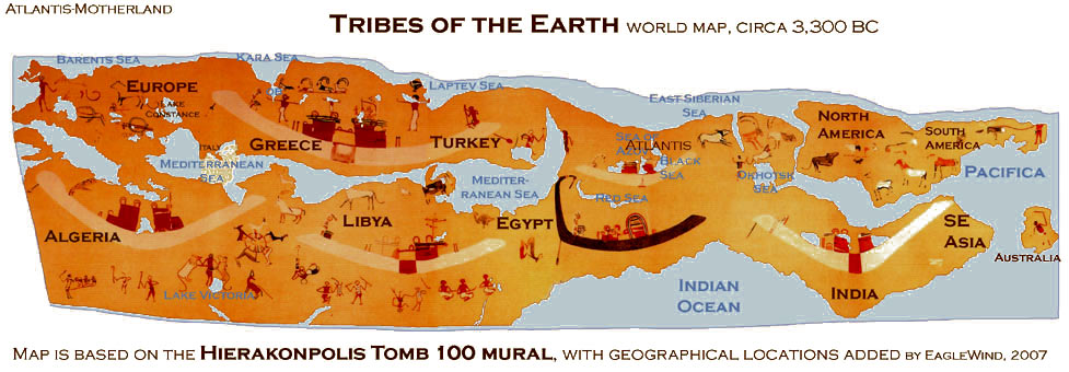
Egyptian Tomb 100 World Map
While studying a copy of an ancient Egyptian tomb painting, known as the Hierakonpolis Tomb 100 mural, we noticed that this ancient artwork displays significant resemblance to a map of the entire world. Is it possible that this map, recorded by Egyptians over 5,000 years ago, was the first world map?
Only fragments of the original mural remain, but fortunately detailed scientific studies of the tomb and artwork were conducted from 1890 to 1910. Studies of this important site continue to this day. The mural we were studying was drawn by F.W. Green of Cambridge, and published by the British School of Egyptian Archeology, in 1902.
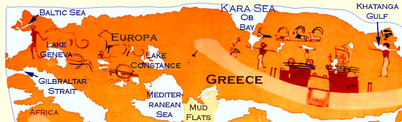
The remarkable similarities between the Tomb 100 mural and the outlines of a world map quickly became obvious to us. Adjusting the darker background color of the Tomb 100 mural to blue emphasized the contrast between the land and the sea. The continents, oceans, inland seas, and even large lakes, mud flats, and straits were easy to identify.
We began calling the mural the Tribes of the Earth World Map because we noted the various civilizations marked on the map, which we propose are represented by the boats.
This fascinating, and now controversial, ancient artwork revolutionizes ancient world history and sheds new light on the adventurous spirit and sailing ability of ancient Egyptian mariners, which charted the farthest boundaries of Mother-Gaia, and successfully recorded the great streams of Oceanus over 5,000 years ago.
Ancient Geography and Sea Levels were accurately recorded 5 kya.
The Tomb 100 map shows an amazingly accurate knowledge of the geography and bathymetry of the ancient world. The Mediterranean Sea is shown much shallower than it is today, which is consistent with the modern theory of global sea level rise. The map shows mud flats, with shallows and channels, in the Mediterranean Sea.
We the predynastic Egyptians sailing around the world, or perhaps, the map was created with the help of older records which were scribed by the Atlanteans, before the great Atlantis flood, at the end of the Younger Dryas ice age, in 9,600 BC.
People, animals and early symbols of familar Egyptian icons are depicted.
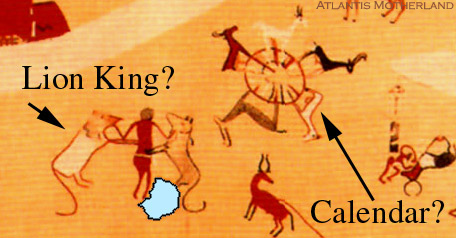
The Lion-King of North Africa
The human figures, boats, animals and structures of the mural, are early pictographs that will develop into well known images, later in dynastic Egypt. The depiction of a mighty hero or king, holding two lions by the throat, is the first known depiction of this famous symbol, which became a common symbol in Mesopotamia, six-hundred years later.
Located next to the Lion-King, there is a depiction of a circle with five stags surrounding it. The animal-wheel has been interpreted as a calendar, showing 5 seasons to the year, depicted by the five stags. Perhaps the calendar was used as a symbol for their culture, for example, as the Mayan calendar is often used today, as a symbol of the Mayan civilization.
The five stags may also represent a unification of five different tribes. Perhaps the circle marked a city, gathering place, or a great bazaar, where the tribes came together, five times a year to trade their produce, animal skins, and other products.
A high-prowed boat is the symbol of Egypt
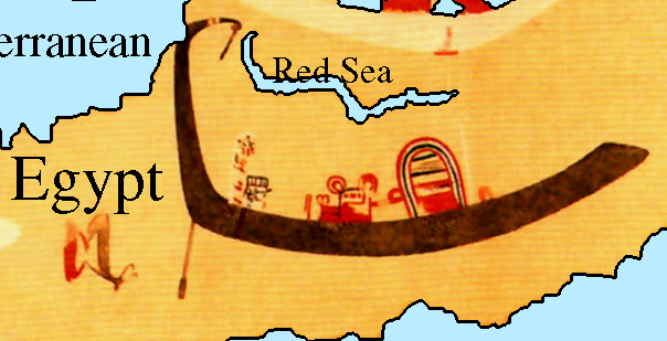
Ancient Map of Egypt and the Red Sea
Prominently located, near the center of the mural is a high-prowed dark-boat, which stands out in contrast to the five white boats surrounding it. The high-prowed dark-boat is the symbol of Egypt. Egypt has a central location and the most outstanding boat. Perhaps the dark-boat is actually symbolic of the Nile River, and honors the gods that preserve the flow of its life-giving waters.
The five white boats represent other major nations of the world, at that time.
Evidence of ancient horses in the Americas
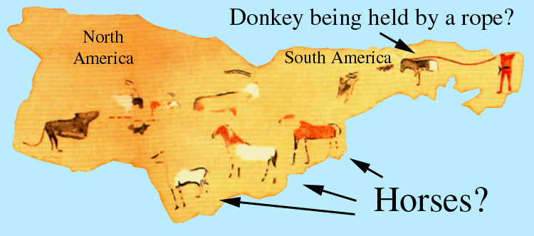
Ancient Map of North and South America
The familiar contours of North and South America are unmistakable. The date of Tomb 100 map in circa 3,300 BC is just before the beginning of the Mayan Calendar in 3,114 BC. The mystery of the similarities in art and architecture between the early meso-Americans and Egyptians is solved by the revolutionary new timetable of early contact established by this map.
It is surprising to see horses in South America, because horses are thought to have become extinct in both North and South America, about 10,000 BC, and were absent until reintroduced by the Spanish conquests. Whether or not these images are actually horses has been debated. Most folks see horses, especially when comparing the nearby image of what looks, very much, like a donkey on a rope. Some have speculated that they are llamas.
A procession of boats sails across millennia of time, transporting a mysterious cargo of ancient knowledge;
Long ages of time before Ulysses, Odysseus, and the Argonauts, an ancient pre-Egyptian mariner
launch an epic voyage; circumnavigating the world ... over 5,000 years ago.
Back to Atlantis Today
|